


The NISAR satellite, a major joint mission between NASA and ISRO, is set to launch today, July 30, 2025, from the Satish Dhawan Space Centre in Sriharikota. The much-anticipated NISAR launch date marks a significant step in Earth observation. Designed to closely observe Earth’s surface, this advanced satellite uses dual radar systems to capture clear images—even through clouds or darkness. It’s a breakthrough in how we monitor our planet from space.
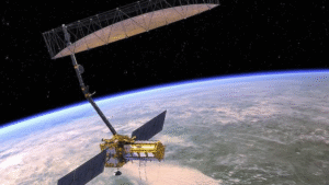
This India–US space project shows how both countries are working together in a historic NASA ISRO collaboration to tackle global environmental problems using science and technology. Fast and accurate, the NISAR satellite will scan the entire planet every 12 days. It will track changes in glaciers, forests, water levels, soil moisture, and even shifts in the ground. The satellite’s detailed imaging—able to detect movements as small as a few millimeters—will help governments, scientists, and emergency teams respond better to environmental and natural challenges.
Why the NISAR Satellite is a Game-Changer for Earth Observation
Disaster Management: The NISAR satellite is expected to play a critical role in natural disaster response. Its radar system can provide near real-time imaging of areas affected by earthquakes, floods, volcanic eruptions, and landslides. This allows emergency responders to map damage zones, track the progression of disasters, and coordinate relief operations more efficiently. Governments will be able to allocate rescue resources based on fresh, accurate satellite data instead of delayed ground reports. This makes it a centerpiece of NASA ISRO collaboration in real-time response to natural calamities.
Climate Monitoring: As the pace of global warming accelerates, the need for reliable Earth data has never been greater. NISAR will observe key climate indicators including glacial melt, sea-level rise, permafrost degradation, and long-term land surface changes. The insights gained from this mission will feed directly into climate models, helping scientists forecast regional effects of climate change with greater precision. These models are crucial for planning national climate adaptation and mitigation strategies. The NISAR satellite, set for launch on this historic NISAR launch date, will be a major contributor to global climate surveillance.
Agricultural Forecasting: For countries dependent on agriculture, the NISAR satellite will provide timely data on crop conditions, irrigation levels, and soil health. Its sensors will track patterns in land use, enabling predictions about harvest yields and helping detect early signs of drought or land degradation. This information can support decisions about water distribution, fertilizer use, and food supply management—especially in monsoon-driven economies like India’s.
Urban and Infrastructure Planning: NISAR’s high-resolution radar will help identify land subsidence, structural shifts, and stress points in urban infrastructure. Cities facing rapid population growth and expanding construction can use this data to monitor the health of roads, dams, bridges, and high-rise buildings. By measuring subsurface changes that are invisible to the naked eye, the satellite reduces the risks associated with undetected ground movement and infrastructure failure.
Forest and Biodiversity Conservation: One of NISAR’s unique strengths is its ability to penetrate dense vegetation. This feature makes it invaluable for monitoring forests and tracking biodiversity loss. Conservation agencies will be able to detect illegal logging activities, assess forest health, and monitor habitat encroachment. The satellite’s consistent data stream will also assist in protecting endangered ecosystems by offering scientific evidence of change over time.
A symbol of international cooperation
The NISAR satellite stands as a clear symbol of successful NASA ISRO collaboration between two major space agencies. NASA contributed the satellite’s L-band radar system, payload electronics, and engineering support. ISRO developed the S-band radar and is responsible for the satellite’s integration and launch. The GSLV-F16 rocket, which will carry the satellite into orbit, represents India’s heavy-lift capabilities and growing leadership in launch technology. This GSLV-F16 rocket launch on the current NISAR launch date is drawing global attention.
Together, the two agencies have created one of the most sophisticated Earth observation missions to date. The mission’s open data policy ensures that satellite imagery will be freely available to researchers and government agencies across the globe. This transparency fosters international cooperation in science, disaster preparedness, environmental protection, and sustainable development.
Powered by technology, guided by purpose
The mission cost, estimated at $1.5 billion, reflects both the technological complexity of the satellite and the value it brings to global monitoring systems. Over the next three to five years, the NISAR satellite is expected to generate a steady stream of high-quality geospatial data that will inform decisions at local, national, and international levels. As part of the NASA ISRO collaboration, this satellite will drive innovation across many critical sectors.
From strengthening flood prediction systems in Bangladesh to tracking permafrost changes in the Arctic, the applications of NISAR’s radar imaging are vast. The satellite is not just a scientific achievement; it is a working solution to real-world problems. As the GSLV-F16 rocket carries it into orbit, this mission becomes a global highlight across Breaking News and Latest News platforms.
With NISAR in Orbit, India and the US Strengthen Global Earth Monitoring Capabilities
The launch of the NISAR satellite is more than a technological milestone—it is the beginning of a new era in Earth observation. By blending cutting-edge science with shared international vision, this mission sets a benchmark for how space research can directly benefit humanity. As it begins its journey in orbit, NISAR promises to deliver the data we need to understand our planet—and protect it.
Stay tuned to Quirk Report for continued coverage on this and other Latest News, Breaking News, and Today’s Top Stories in science, space, and global affairs.